Cincinnati weather alert: Southwest Ohio, NKY at risk for tornadoes, severe storms Tuesday
Severe Weather Discussion for Tuesday, April 2. pic.twitter.com/d30EoCbBir
— NWS Storm Prediction Center (@NWSSPC) April 2, 2024
Check here for latest updates: What we know about the risk of tornadoes on Tuesday
Update, 7:10 a.m.: A tornado watch has been issued for parts of Kentucky.
The watch is valid until noon and covers Carroll, Gallatin, Owen, Grant, and Pendleton counties among others in Kentucky.
[7:00 AM] A Tornado Watch has been issued for portions of our area. pic.twitter.com/EkxDpy4oP3
— NWS Wilmington OH (@NWSILN) April 2, 2024
A strong thunderstorm is moving east across the region at 55 mph early Tuesday, according to the National Weather Service in Wilmington.
Wind gusts up to 40 mph, which could knock down tree limbs and blow around unsecured objects were listed as the main impact from the storm.
A flood watch is in effect. A hazardous weather outlook is also in effect for all counties in the region.
The weather service said in a post on X early Tuesday that a "significant weather event is expected today," with a round of storms in the morning and additional rounds in the afternoon and evening.
Here's what to expect:
In the morning, 6-11 a.m.: a few severe storms will be possible. Damaging wind and large hail will be the main severe weather threat, although a tornado cannot be ruled out. Heavy rain will lead to the threat of flash flooding.
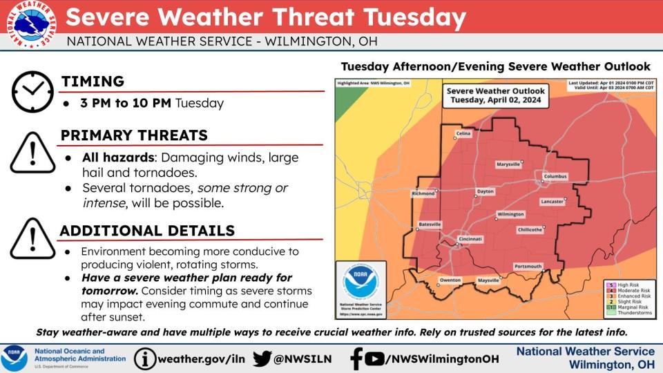
In the afternoon, 3-10 p.m.: Additional showers and thunderstorms will develop late Tuesday afternoon and into the evening. Some severe storms can be expected between 3 and 10 p.m. with the potential for all weather hazards. Damaging winds, large hail, and several tornadoes, some strong or intense, will be possible.
Several tornadoes are possible with the chance for a few long-tracked, strong tornadoes.
The National Weather Service forecast discussion states, "Impressive deep layer shear of 60-80 knots will be present across the region, coupled with strong 0-1 km and 0-3 km shear, leading to the potential for supercell development from mid to late afternoon, with activity then continuing into early evening. All severe weather types will be possible this afternoon into early evening, including the potential for a few stronger tornadoes."
- Cheryl Vari
Update, 6:30 a.m.: A strong thunderstorm is moving east across the region at 55 mph early Tuesday, according to the National Weather Service in Wilmington.
Wind gusts up to 40 mph, which could could knock down tree limbs and blow around unsecured objects was listed as the main impact from the storm.
A flood watch is in effect. A hazardous weather outlook is also in effect for all counties in the region.
The weather service said in a post on X early Tuesday that a "significant weather event is expected today," with a round of storms in the morning and additional rounds in the afternoon and evening.
Here's what to expect:
In the morning: a few severe storms will be possible. Damaging wind and large hail will be the main severe weather threat, although a tornado cannot be ruled out.
In the afternoon: Additional showers and thunderstorms will develop late Tuesday afternoon and into the evening. Some severe storms can be expected between 3 and 10 p.m. with the potential for all weather hazards. Damaging winds, large hail, and several tornadoes, some strong or intense, will be possible.
The National Weather Service forecast discussion states, "Impressive deep layer shear of 60-80 knots will be present across the region, coupled with strong 0-1 km and 0-3 km shear, leading to the potential for supercell development from mid to late afternoon, with activity then continuing into early evening. All severe weather types will be possible this afternoon into early evening, including the potential for a few stronger tornadoes."
- Cheryl Vari
[4:50 AM] A significant severe weather event is expected today. We will have one round of storms this morning, and additional storms this afternoon and evening. All types of severe weather are possible, with a risk of strong tornadoes this afternoon. pic.twitter.com/MjA7576T0A
— NWS Wilmington OH (@NWSILN) April 2, 2024
Update, 5:30 a.m.: The National Weather Service in Wilmington has issued a Severe Thunderstorm Warning for parts of the region until 6:15 a.m.
The warning covers northern Kenton County, northern Campbell County and Boone County in Northern Kentucky; central Hamilton County in Southwest Ohio; and Ohio, Ripley and Dearborn counties is southeastern Indiana.
A series of storms that could produce strong winds, hail or tornadoes will impact the Greater Cincinnati region Tuesday.
The primary threat is gusts up to 60 mph and possibly hail, which could cause damage to trees and power lines.
- Cheryl Vari
Update: 5:15 a.m.: The weather service has issued a hazardous weather outlook. A flood watch also is in effect.
The weather service said in a post to X early Tuesday that a "significant weather event is expected today," with a round of storms in the morning and additional rounds in the afternoon and evening.
In the morning: a few severe storms will be possible. Damaging wind and large hail will be the main severe weather threat, although a tornado cannot be ruled out.
In the afternoon: Additional showers and thunderstorms will develop late Tuesday afternoon and into the evening. Some severe storms can be expected between 3 and 10 p.m. with the potential for all weather hazards. Damaging winds, large hail, and several tornadoes, some strong or intense, will be possible.
- Cheryl Vari
Previous report: Meteorologists with the National Weather Service at Wilmington are calling for several thunderstorms early Tuesday. Some storms could be severe with large hail, damaging winds and heavy rain.
A tornado cannot be ruled out.
Severe thunderstorm watch issued
The weather service issued a severe thunderstorm watch Monday at 8:38 p.m. until April 2 at 3 a.m. for Dearborn, Fayette, Franklin, Ripley, Union and Wayne counties in Indiana and Butler, Darke, Hamilton, Miami, Montgomery, Preble, Shelby and Warren counties in Ohio.
Northern Kentucky counties were not part of the watch area, although they were included in an area of moderate risk for severe weather on Tuesday.
What is a severe thunderstorm watch?
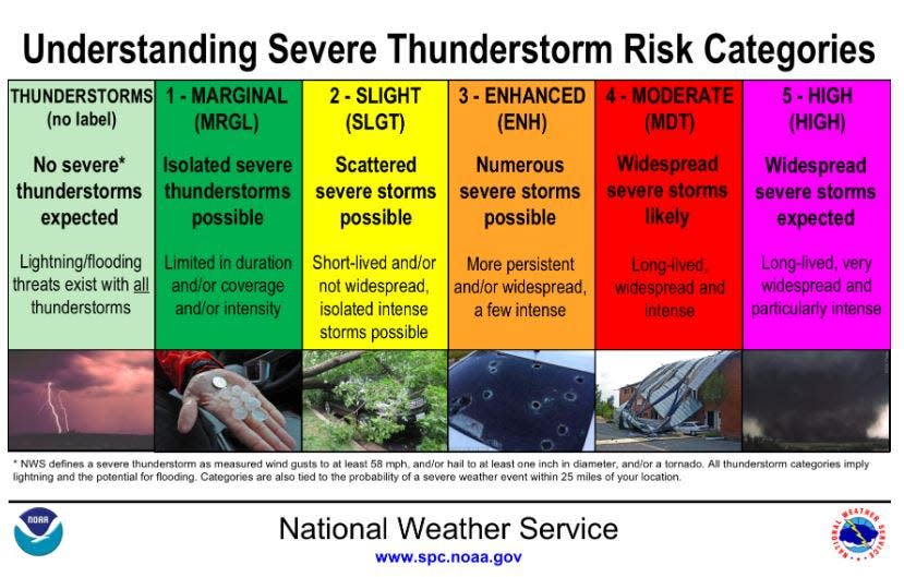
The National Weather Service says a severe thunderstorm watch is issued when severe thunderstorms are possible in and near the watch area. It does not mean that they will occur. It only means they are possible.
Severe thunderstorms are defined as having winds of 58 mph or higher and/or having hail 1 inch in diameter or larger.
Will Cincinnati get a tornado?
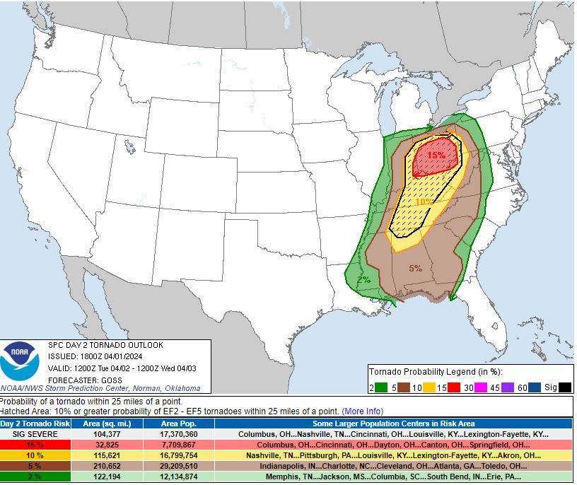
Several tornadoes, some strong or intense, will be possible. There is a 15% probability of an EF2 to EF5 tornado, a "moderate" risk.
Showers and thunderstorms will redevelop Tuesday afternoon and evening. Those storms will likely be strong to severe, according to the service's hazardous weather outlook.
A cold front will move through the area Tuesday night, ushering in a cooler airmass for the middle of the week, according to forecasters. Temperatures will cool from the late 50s and early 60s to as low as 34 on Wednesday night, when a rain/snow mix is possible.
Cincinnati flood warning: What's the status?
A flood watch will remain in effect in the Cincinnati region until 8 p.m. Tuesday. One to 2 inches of rainfall is possible.
There will be an uptick in flash flooding late in the overnight into Tuesday morning if the current weather trends continue. This may impact the morning commute with water-covered roadways and possible road closures, according to forecasters.
What is the forecast?
Monday night: Showers likely and possibly a thunderstorm before 1 a.m., then showers and thunderstorms likely between 1 a.m. and 2 a.m., then showers and possibly a thunderstorm after 2 a.m. Some storms could be severe, with large hail, hail, damaging winds, and heavy rain. Low around 60. South wind around 6 mph. Chance of precipitation is 100%. New rainfall amounts between 1 and 2 inches possible.
Tuesday: Showers and possibly a thunderstorm before 10 a.m., then showers and thunderstorms likely, mainly after 5 p.m. Some storms could be severe, with heavy rain. High near 73. Southwest wind 11 to 16 mph, with gusts as high as 28 mph. Chance of precipitation is 80%. New rainfall amounts between three quarters and one inch possible.
Tuesday night: Showers and thunderstorms before midnight, then a slight chance of showers after 5 a.m. Some storms could be severe, with heavy rain. Low around 39. Southwest wind 11 to 15 mph. Chance of precipitation is 80%. New precipitation amounts between a tenth and quarter of an inch, except higher amounts possible in thunderstorms.
Wednesday: Showers, with thunderstorms also possible after 5 p.m. High near 48. Southwest wind 11 to 16 mph, with gusts as high as 26 mph. Chance of precipitation is 90%. New rainfall amounts of less than a tenth of an inch, except higher amounts possible in thunderstorms.
Wednesday Night: Rain showers before 11 pm., then rain, possibly mixed with snow showers. Some thunder is also possible. Low around 35. West wind 11 to 13 mph. Chance of precipitation is 80%. Little or no snow accumulation expected.
Thursday: Rain likely, possibly mixed with snow showers before 2 p.m., then a chance of rain showers. Mostly cloudy, with a high near 46. Chance of precipitation is 60%. Little or no snow accumulation expected.
Thursday Night: A chance of showers before 8 p.m. Mostly cloudy, with a low around 34. Chance of precipitation is 30%.
Friday: Partly sunny, with a high near 48.
Friday Night: Partly cloudy, with a low around 31.
Saturday: Sunny, with a high near 55.
Saturday Night: Mostly clear, with a low around 34.
Sunday: Sunny, with a high near 62.
Sunday Night: Partly cloudy, with a low around 43.
Source: National Weather Service at Wilmington.
This article originally appeared on Cincinnati Enquirer: Tornado watch: severe storms expected in Ohio, Kentucky on April 2

